Description des Alpes Pennines et Rhetiennes…
Eight engraved plates & one folding engraved map. xix, 247 pp.; 2 p.l., 285 pp. Two vols. 8vo, cont. mottled calf (extremities a bit rubbed), flat spines gilt. Geneva: J.P. Bonnant, 1781 [an early owner has added two I’s the Roman numeral date making it “1783”].
First edition and rather scarce. Bourrit (1735-1815), the son of a watchmaker in Geneva, was one of the first to systematically explore and record the Alps and their geological features. In the years 1784-85 he was the first to attempt the ascent of Mont Blanc (not conquered until 1786). In 1787 he reopened the route over the Col de Géant (11,060 ft.), which had fallen into oblivion.
While mostly concerned with the natural wonders and complex geology of the mountain chains, Bourrit does provide accounts of the natural history cabinets in Switzerland, the leading intellectuals of Geneva including Saussure and Deluc and their collections, accounts of various towns and villages, customs, etc.
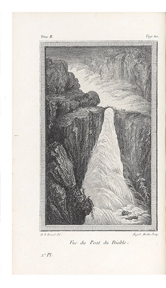
The plates depict the glacier of Chermotane (two different views), Valais and the Rhone, the lake at Kandel, the Rhone glacier which is the source of the Rhone, the famous “Pont du Diable,” the glacier at Grindelwald, and a view of Mount Blanc.
Fine and pretty set.
Price: $2,500.00
Item ID: 5967

