
Voyage en Crimée et sur les Bords de la Mer Noire, pendant l’année 1803; suivi d’un Mémoire sur le Commerce de cette Mer, et de Notes sur les principaux Ports commerçans.
Five head-pieces, one tail-piece, two folding maps, three folding plates (all engraved), & three folding printed tables. 4 p.l., xix, 302 pp., one leaf of errata. 8vo, cont. marbled sheep (head of lower joint a little split), flat spine richly gilt, red morocco lettering piece on spine. Paris: Bossange, 1806.
First edition of an important book on the Crimea; it also contains descriptions of previously unrecorded coins and medals from the area. Reuilly (1780-1810), man of letters and diplomat, traveled extensively in eastern Europe. In 1803, Reuilly joined the staff of the Duc de Richelieu, the recently named governor of Odessa. Befriended by the German naturalist Pallas, the two travelled throughout southern Russia, especially the Crimea, and even to the Azov Sea.
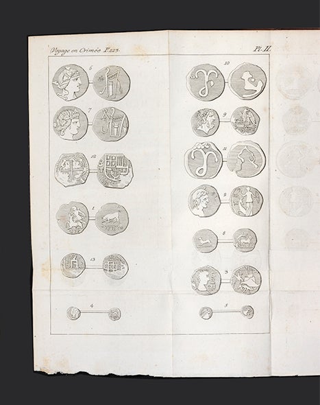
The first part of this work provides a history of the region, before and after the Russian annexation in 1783, and describes the climate, natural resources, its inhabitants, customs, etc. There is a most interesting chapter devoted to Crimean coins and medals, of which little was known at the time. Reuilly formed a large collection of coins and medals, notable for the Greek, Byzantine, Scythian, and Crimean examples, which he later donated to the Royal Library. Pages 233-40 present the itinerary of Reuilly and Pallas.
The second part of the work details the commercial activities of the Black Sea region, including agriculture, fishing, and industry. There are also descriptions of the most important ports including Sevastopol, Odessa, Kherson, and Feodosia. Pages [285]-302 contain an invaluable vocabulary of local words.
The first map depicts Sevastopol and its environs. The second large map, of the Crimea and southern parts of modern-day Russia, was compiled by Jean-Baptiste Poirson. The three engraved plates are some of the earliest images of coins and medals found in the area. The three tables present data on the exports and imports of the region.
Very good copy with infrequent foxing.
Bookplate of Alexandre-Auguste Ledru-Rollin (1807-74), French politician.
❧ N.B.G., Vol. 41, cols. 60-61.
Price: $1,500.00
Item ID: 5637


